

Water level monitoring with LoRaWAN sensors
A LoRaWAN water level sensor measures the height of the water in a river, lake, reservoir, or canal and transmits the reading by radio over a range of kilometers, with no cables and no mains power. The readings flow into a platform that shows the water level trend in real time and sends an alarm when a threshold is crossed. A measuring station goes up in a few hours on a bridge, a bank, or a well, and the battery lasts for years. We explain the technologies used to measure water level, where the sensors are installed, and how the data becomes a flood early warning system.
How water level is measured: the technologies compared
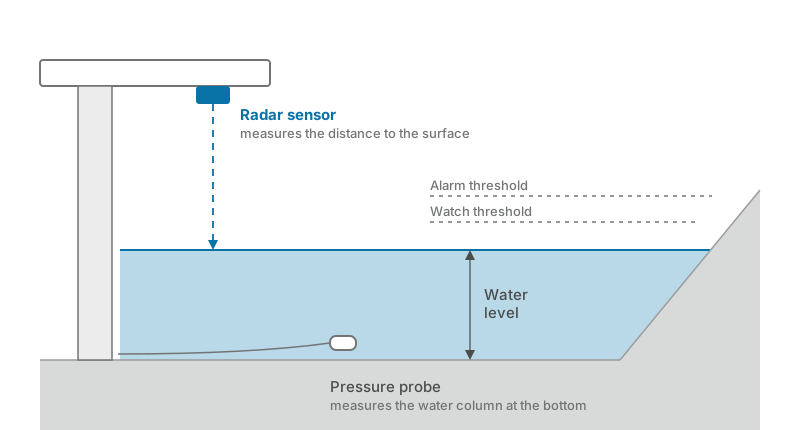
Water level is measured with four families of sensors. The first two work from above, without touching the water; the other two work submerged or in contact with the surface.
| Technology | How it measures | Strengths | Limitations |
|---|---|---|---|
| Radar | Distance to the surface, from above | No contact with the water, millimeter accuracy | Needs a structure above the water surface |
| Ultrasonic | Distance to the surface, from above | Low cost | Sensitive to wind, temperature, and foam |
| Pressure probe | Water column above the submerged probe | Suited to wells, groundwater, and deep reservoirs | In contact with water and sediment |
| Float gauge | Position of the float in a stilling well | The historical standard of river gauging networks | Requires civil works and mechanical maintenance |
For rivers and canals, radar is now the reference choice: it measures without touching the water, stays out of reach of sediment and debris, and keeps its accuracy even during a flood. The submersible pressure probe remains the best fit for wells, groundwater, and deep reservoirs.
Where the sensors are installed
The radar sensor mounts on an existing structure above the water surface: the deck or parapet of a bridge, a footbridge, or a cantilever arm on a bank. The measuring point must stay above the maximum flood level and clear of obstacles in the measuring cone.
The submersible water level sensor is lowered to the bottom, protected by a guide pipe or a well, with the LoRaWAN transmitter at the surface. It is the typical setup for monitoring wells, tanks, and reservoirs.
Beyond the main watercourses, the same sensors cover the smaller critical points that institutional gauging networks do not watch: drainage canals, underpasses, culverts, and crossings that flood first during an intense event.
The LoRaWAN network: range and battery life
The sensors transmit their readings on the license-free 868 MHz band using the LoRaWAN protocol: a single gateway receives data from dozens of measuring stations within a radius of kilometers, even in hilly terrain, and at sites with no power supply the gateway runs on a solar panel. Many cities and regions already operate a public LoRaWAN network: where one exists, the stations join the existing gateways.
Power consumption is minimal: with a reading every 5–15 minutes the internal battery lasts from 5 to over 10 years, and each device periodically reports its own health status along with the battery level. The parameters, measuring interval included, can be changed remotely over the air. It is the same infrastructure we describe for ski resort monitoring and parking monitoring: one network, many families of sensors.
From sensor to platform: thresholds and alarms
The gateway forwards the radio packets to a network server, the software that manages the devices and decodes the readings: the most common choice among public authorities is ChirpStack, open source and license-free. From there, the data reaches applications through open protocols such as MQTT and REST APIs.
On the platform, each station becomes a point on a map with the historical level chart. You can define multiple thresholds for each measuring point, receive notifications on your configured channels as soon as a threshold is crossed, and export the measurement series for studies and design work. With our monitoring platform Track-TP, water levels sit alongside data from network equipment and other IoT sensors, on a single dashboard with alarms and notifications.
Flood early warning
The value of river water level monitoring shows during intense events. When the level crosses the watch threshold, the sensor raises its transmission rate on its own and the platform alerts the on-call staff: decision-makers get real-time data for their own territory, minutes or hours ahead of the critical point.
Thresholds are calibrated on local references: the height of the embankment, the level of the road surface, or the safety clearance of a crossing. The measurement history then supports planning: reconstructing an event, sizing an intervention, and documenting how well a flood defense performs.
What a water level monitoring project involves
A complete project develops in four steps:
- Site survey and choice of measuring points. We identify the significant river sections, the mounting structures, and the elevation reference for each station.
- Radio coverage check. We verify the coverage of existing gateways and add the receiving points needed, with solar panels where power is not available.
- Installation and calibration. Sensor mounting, verification of the reading against the elevation reference, and acceptance testing of transmission to the platform.
- Platform and maintenance. Configuration of thresholds and notifications, periodic calibration checks, and planned replacement of the batteries flagged by diagnostics.
Teleproject designs and builds complete LoRaWAN networks for public authorities, consortia, and infrastructure operators: from radio coverage checks to sensor supply and installation, through to platform configuration and ongoing technical support. Explore our IoT and LoRaWAN solution.
Frequently asked questions
How long does the battery of a LoRaWAN water level sensor last?
From 5 to over 10 years with a reading every 5–15 minutes. The transmission rate drives the consumption: raising it only when a threshold is crossed, as the latest generation of sensors does, keeps multi-year battery life even at the most closely watched points. The battery level reaches the platform with the periodic diagnostics.
Does the measurement work during a flood?
Yes, if the station is well designed: the radar works from above, without touching the water, and must be installed above the maximum flood level, sheltered from the current and from debris. With an IP68 protection rating and the automatic increase in measuring rate, the station keeps transmitting exactly when the data matters most.
Do you need to build a dedicated radio network?
Not always. Many cities and regions operate a public LoRaWAN network open to local authorities: where coverage exists, the stations register on the existing gateways. In valleys and isolated sites, a few dedicated gateways are enough, solar-powered where mains power is missing.
How accurate is the water level measurement?
Radar sensors are accurate to the millimeter, pressure probes to the centimeter. For an early warning system that is more than enough: the watch and alarm thresholds sit tens of centimeters apart.
What maintenance does the system require?
Little, and it can be planned. The radar does not touch the water and does not build up sediment; the submerged probe needs periodic cleaning. Remote diagnostics flag depleting batteries and transmission anomalies, so you can schedule interventions instead of reacting to failures. An annual calibration check completes the plan.