

Drive test: measuring the cellular network in the field
An RF drive test, also known as drive testing, measures a cellular network from a moving vehicle: a broadband scanner records, meter by meter, the level and the quality of the 2G, 3G, 4G, and 5G signal of every operator present along the route. Here is how it works, which parameters are measured for each technology, which thresholds separate good coverage from insufficient coverage, and how to read the results. It is the method we use to verify the real coverage of highways, roads, and tunnels: not an estimate calculated at a desk, but the signal users actually receive in the field.
What a drive test is
A drive test measures the coverage of a network already in service by driving the route with an instrumented vehicle. A coverage study simulates signal propagation before the network is built; a drive test photographs the real situation instead: which operators you receive, at what level, at what quality, and at exactly which points along the route. In telecommunications it is the reference method for assessing the performance of a mobile network in the field.
It is usually commissioned by whoever needs objective evidence about the level of service: highway concessionaires that want to know the cellular coverage available to drivers in transit, infrastructure managers that have to accept a tunnel coverage system, operators of airports, stations, and large buildings that have to verify the coverage of the DAS systems inside them, and public authorities that check coverage obligations across a territory.
The same measurement does not stop where the road ends. Inside airports, stations, hospitals, and large buildings it is carried out on foot (walk test), with the scanner on a trolley or in a backpack. What changes is the means of transport, not the method.
The result is a complete, georeferenced picture: every measured value is tied to the exact point where it was recorded, so you can see on a map where coverage is good, where it degrades, and where it is missing.
How it works: the vehicle, the scanner, and the antennas
The measuring instrument is a broadband scanner, in our case a Rohde & Schwarz TSMA6, installed on board the vehicle. A phone locks onto one cell at a time, and only on the network its SIM belongs to. The scanner instead receives all the carriers of all operators in parallel, band by band, without interruption. Alongside it runs the Rohde & Schwarz ROMES measurement software, which records and synchronizes the data collected along the route.
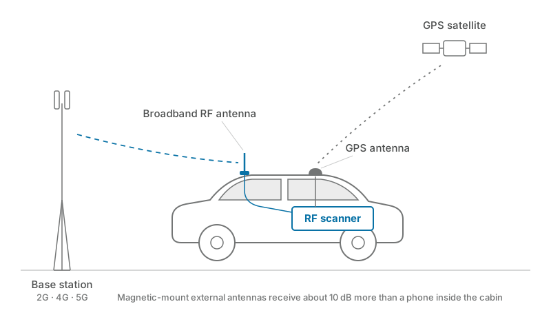
Two magnetic-mount antennas are installed on the vehicle roof: a broadband RF antenna, which receives the cellular signal across the whole frequency spectrum, and a GPS antenna, which records the exact geographic position of every value collected. The difference matters: the external antenna receives about 10 dB more than a phone resting on the dashboard, so the measurement is cleaner and repeatable.
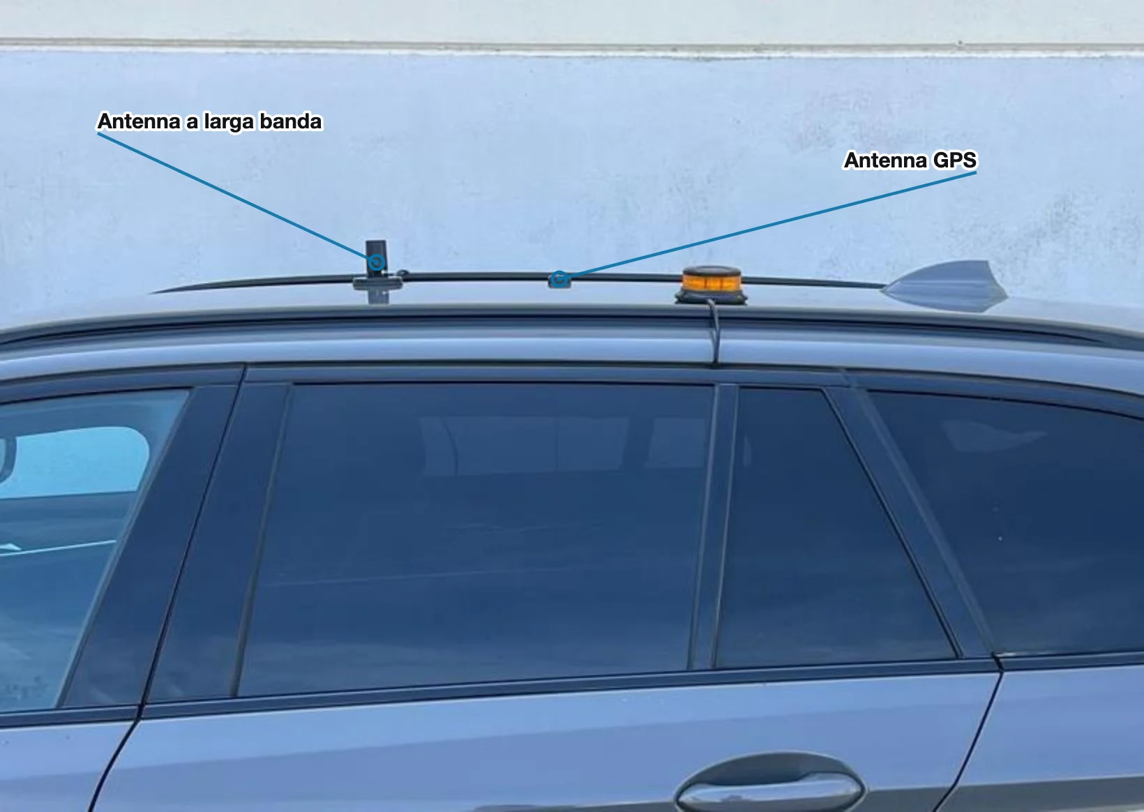
The measurement is taken at constant speed, typically 80 km/h on a highway, because that is the best condition for continuous, comparable data along the entire route. To hold that speed without interfering with traffic, our technicians run the surveys at night.
Which parameters a 4G and 5G drive test measures
Every network technology has its own reference parameters: one describes the received signal power (coverage), the other the ratio between signal and interference (quality). The scanner records both for every carrier it detects, together with the identifier of the cell transmitting it.
| Technology | Coverage | Quality | Cell identifier |
|---|---|---|---|
| 2G GSM | PSCH (dBm) | C/I (dB) | CI |
| 3G UMTS | RSCP (dBm) | Ec/Io (dB) | CI |
| 4G LTE | RSRP (dBm) | SINR (dB) | PCI |
| 5G NR | SS-RSRP (dBm) | SS-SINR (dB) | PCI |
In short: for 4G and 5G the values to look at are RSRP for coverage and SINR for quality, the modern equivalents of what PSCH and C/I represent for GSM.
The measured values are then compared with the thresholds that separate good coverage from weak or unstable coverage:
| Technology | Good coverage from | Good quality from |
|---|---|---|
| 2G GSM | PSCH ≥ −82 dBm | C/I ≥ 16 dB |
| 3G UMTS | RSCP ≥ −90 dBm | Ec/Io ≥ −21 dB |
| 4G LTE | RSRP ≥ −90 dBm | SINR ≥ 4 dB |
| 5G NR | SS-RSRP ≥ −95 dBm | SS-SINR ≥ 0 dB |
Below these thresholds coverage can be weak or unstable: the phone stays connected, but calls degrade and data transmission slows down. The two values have to be read together, because a strong signal with heavy interference is worth little.
Which operators a drive test detects
The scanner detects every operator that transmits on its own network in the country where the measurement is taken. The measurement is passive: no SIM is needed, no agreement with the operators is needed, and the result is independent, because every network is recorded with the same instrument under the same conditions. Virtual operators hold no spectrum of their own and ride on the physical networks, so measuring the physical networks describes the coverage of the whole market.
In Italy four operators hold their own spectrum: TIM, Vodafone, WindTre, and Iliad. The Italian network is in transition: TIM and Vodafone have switched off their 3G UMTS networks, Iliad holds no spectrum in the 2G GSM band, and virtual operators such as Kena Mobile, Poste Mobile, and Ho. run on the networks of the four physical operators. To see how the five generations and their bands evolved, read our article on cellular generations from 2G to 5G.
The same applies in every other market: the names of the networks to detect change, the measurement method does not.
| Country | Operators with their own network |
|---|---|
| Italy | TIM, Vodafone, WindTre, Iliad |
| France | Orange, SFR, Bouygues Telecom, Free |
| Germany | Deutsche Telekom, Vodafone, O2 Telefónica, 1&1 |
| Spain | Movistar, Vodafone, MasOrange, Digi |
| Portugal | MEO, NOS, Vodafone, Digi |
| Switzerland | Swisscom, Sunrise, Salt |
| United States | Verizon, AT&T, T-Mobile |
A survey run in France or in Germany produces the same result as one run in Italy: a georeferenced trace for each operator, on the bands in use in that country.
In border areas the scanner also picks up foreign operators: on surveys along the A10 toward France, for example, the carriers of Bouygues Telecom, SFR, Orange, and Free show up.
How to read the results: georeferenced traces and KMZ files
At the end of the survey the data is processed into KMZ files split by section and by operator, ready to open in Google Earth. Every point along the route shows all the technologies and carriers active at that position, with the values measured for each; a color scale immediately highlights the areas with good, weak, or no coverage.
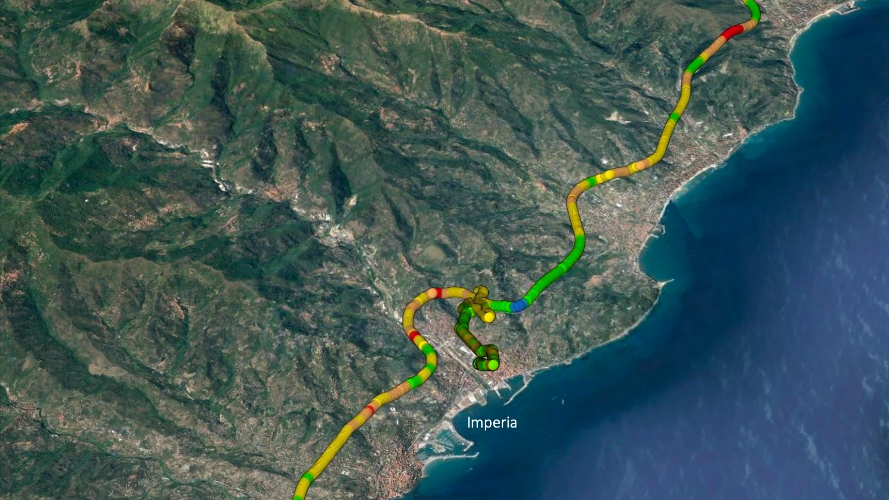
Each carrier also comes with its ARFCN, the radio channel number that gives the carrier frequency and bandwidth: useful for understanding which band each operator is actually transmitting on at that point.
Along with the KMZ files we deliver a technical report with summary tables by operator and technology, highlighting tunnel by tunnel the points where the signal is low or absent. It is the document that lets whoever manages the infrastructure decide where to act.
Drive tests on highways and in tunnels
The highway is the environment where a drive test delivers the most value, because it alternates open stretches and tunnels, and inside tunnels cellular coverage depends on dedicated systems that have to be checked one by one. On stretches with tunnels the survey is run in both directions of travel, because each bore has its own system.
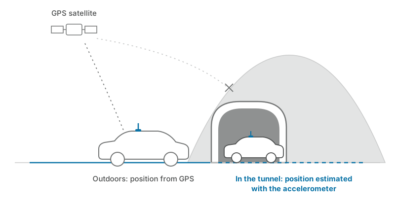
Inside a tunnel the GPS signal does not reach: the scanner estimates the position with its onboard accelerometer, so the measurements taken under the mountain stay accurately georeferenced too.
This is the work we have been doing for years for several Italian highway concessionaires, including Autostrade per l'Italia, RAV, SAV, CAV, and Concessioni del Tirreno: over 3,000 km of highways verified with drive tests and RF measurements, on routes such as the A15 CISA, the A21 Torino–Piacenza, and the A10 Savona–Ventimiglia. In the most recent surveys 5G NR turns out to be present mainly near toll booths and built-up areas, while inside tunnels coverage still rests on 4G and 2G.
Drive test or continuous monitoring?
A drive test and continuous monitoring answer two different questions. The drive test certifies coverage along an entire route at one precise moment: it is the right tool for acceptance testing, a periodic check, or a dispute over the level of service. Continuous monitoring, with fixed probes such as TP-CELLX, watches the critical points 24 hours a day and flags every loss of coverage immediately, as we explain in our guide to monitoring cellular networks and DAS systems.
The two approaches complete each other: the drive test gives you the full picture of the route, fixed monitoring makes sure that no degradation goes unnoticed between one survey and the next. If you want to verify the coverage of your infrastructure, our RF measurements and drive tests service covers 2G, 3G, 4G, and 5G cellular networks, as well as TETRA, DMR, and VHF/UHF.
Frequently asked questions
What is the difference between a drive test and a speed test?
A speed test measures the data speed of your phone, at one point, on your own operator's network. A drive test measures the level and the quality of the signal of every operator along an entire route, with a calibrated scanner and external antennas: it assesses the network, not a single connection.
How is the signal measured in a tunnel, where GPS does not reach?
The scanner has a built-in accelerometer that estimates the position of the vehicle when the GPS signal is not available. The measurements collected inside the tunnel stay georeferenced and comparable with those taken on open-air stretches.
Why is 5G often unavailable in tunnels?
Because the coverage systems installed in tunnels were built for 2G, 3G, and 4G, and the external 5G signal does not penetrate under the mountain. In our surveys on the highway network 5G NR appears near toll booths and built-up areas, while inside tunnels coverage rests on 4G and 2G.
What is the difference between 5G NR and 5G DSS on LTE frequencies?
With DSS (Dynamic Spectrum Sharing) the operator transmits the 5G signal inside the bands already used by 4G LTE, sharing the spectrum between the two technologies: the phone shows the 5G symbol, but speed and capacity stay close to those of 4G. 5G NR on a dedicated band, such as 3.6 GHz, has carriers of its own and delivers the full performance of the network. In a drive test the scanner tells the two cases apart, because for every carrier it records the frequency and the actual technology.
Does a drive test cover virtual operators too?
Yes, indirectly: virtual operators have no network of their own and ride on those of the physical operators. In Italy, for example, Kena Mobile, Poste Mobile, and Ho. run on the networks of the four operators that hold their own spectrum: by measuring those networks, the drive test also describes the coverage their customers get.